Mahalibeh Castle
قلعة المهالبة
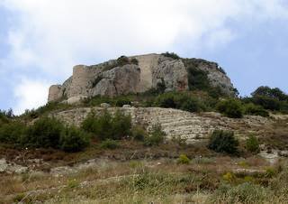
A hilltop castle near Qardaha at about 750 metres, held in turn by the Byzantines, Crusaders, Ayyubids and Mamluks before being abandoned after an earthquake in 1408.
Mahalibeh Castle stands on a high summit in the Syrian coastal mountains near Qardaha, at about 750 metres above sea level and some forty kilometres inland from the coast. It was formerly known as Balatanos or Balatunus, from the Latin platanus, the plane tree, and the village of Mahalibeh lies beside it.
The Banu'l-Ahmar family built the castle in the 11th century, and in 1031 the tribe surrendered it to Niketas of Mistheia of the Byzantine Empire. In 1118 it was taken by the Crusaders under Roger of Salerno; after many clashes and much damage it surrendered to Saladin in 1188 and passed in 1194 to his son al-Zahir Ghazi. The Mamluk sultan Baybars restored it in 1269; in 1280 it was held by the rebel Mamluk emir Sunqur al-Ashqar, before Sultan Qalawun retook it in 1285.
In 1408 a strong earthquake damaged the castle badly and it was abandoned. Under Ottoman rule, at least in the early 17th century, the authorities used it to store state grain and rice. By the early 18th century the castle had become identified with the Muhalaba, a tribal grouping dominant in the area, which Ottoman records also began calling the Muhalaba.
Massive outer walls surround the castle, enclosing cisterns, underground rooms, remains of buildings, and some arches and towers. The only link between the castle and the land around it is a narrow lane on the south side, joined to a paved road that reaches it from Qardaha to the west and Jawbat Burghal to the east.
From its summit above the surrounding mountains and valleys, the castle shows how hill forts guarded the coastal mountain routes in the Middle Ages, passing between successive empires and states.
Note: photos may not reflect the site's current condition.
For the visitor
Location: 35.5081, 36.0869 · Open on the map
Photos: Hovalp at English Wikipedia — via Wikimedia Commons (CC BY-SA)
Syria Trails — An interactive geographic and heritage atlas of Syria: a map that walks down from the country to the district, landmarks with their story and era, curated trails and a passport for your visits.